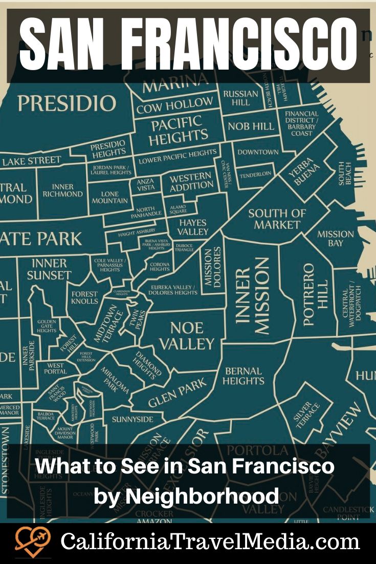
San Francisco Neighborhoods
San Francisco has what can only be described as a ridiculous number of neighborhoods. The whole city is 46 square miles but I swear that if they had their way each San Francisco resident would get their own neighborhood. The good news is that unless you plan to sell or buy real estate in the city, you don’t need to know much more than a dozen neighborhoods.
While I am sure that every neighborhood is a precious snowflake, as a rule, most tourists won’t visit neighborhoods in the southern half of the city. Most of the well-known tourist sites are in the northern half of the city and many tourists will only visit the northeast corner of the city.
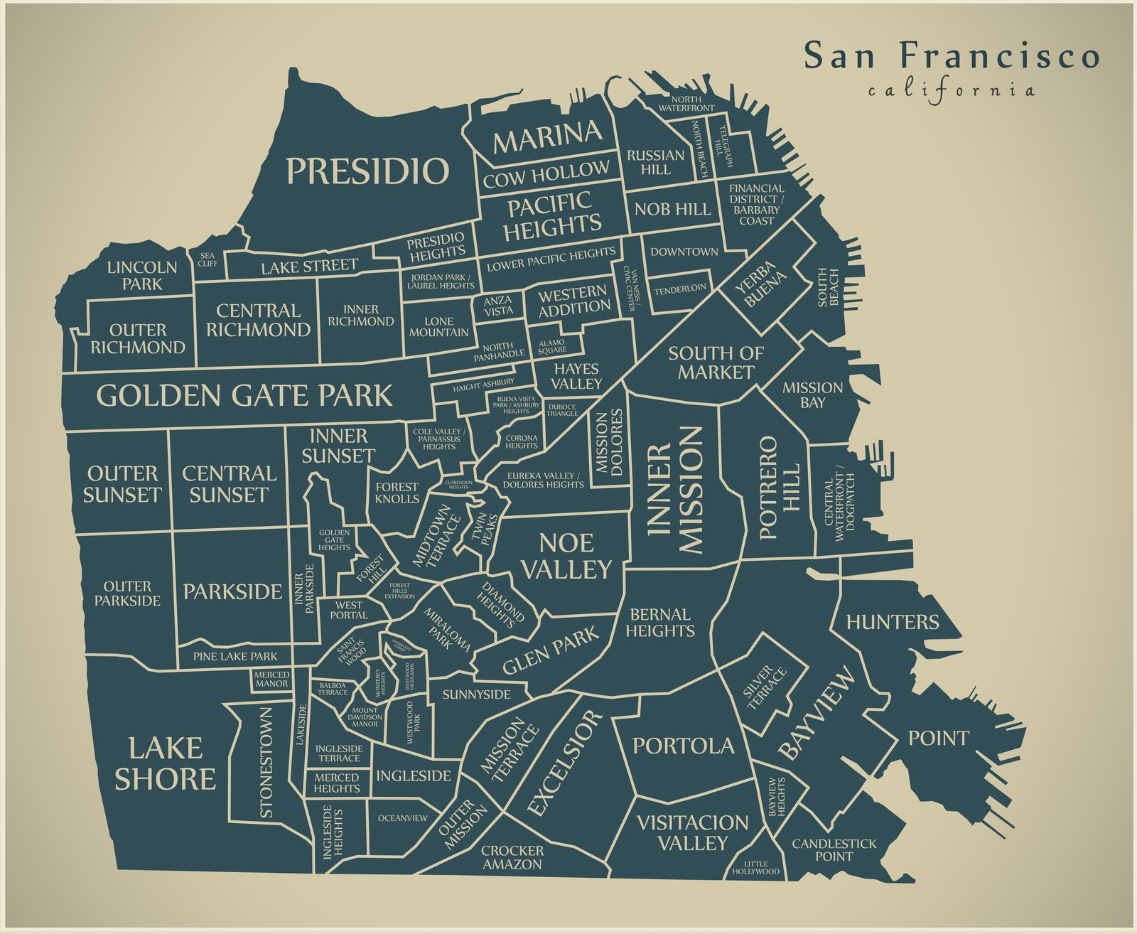
Table of contents: ()
One caveat is that as I researched this article I found maddingly inconsistent ideas of which area was in which neighborhood. Is Telegraph Hill its own neighborhood or is it part of North Beach. Does Russian Hill go all the way to the shore as in the map above or not. I am using the map above to try and break down the neighborhood by neighborhood sites so that at least this article will be internally consistent.
One hint for getting around is that San Francisco is very hilly and you can assume that any neighborhood that includes the word “heights” or “hill” is on one of those hills.
Here are some of the notable neighborhoods and why tourists will visit them. I will start with the area by the Golden Gate bridge and then work my way east. I will skip most of the neighborhoods as I am focusing on what a tourist needs to know.
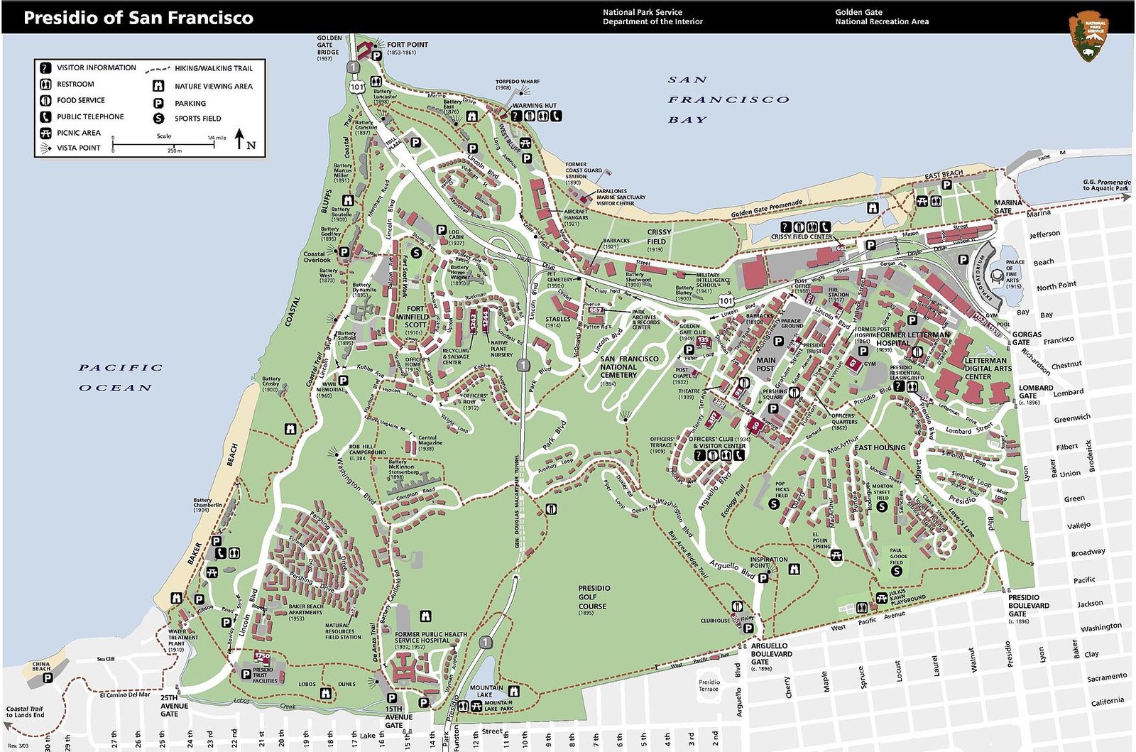
Presidio
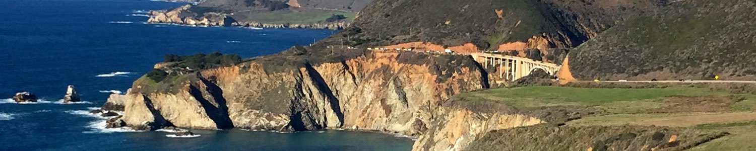
The two largest parks in the city are Golden Gate Park and the Presidio. The Presidio was an army based for most of the city’s history. It started as a Spanish fort, then Mexican and later American. The U.S. Army transferred the area to the National Park Service in 1994. Today it is a multi-use area including parkland, a number of visitor centers, businesses (including Lucasfilm’s Industrial Light & Magic), a golf course, and a beach. The Golden Gate Bridge connects to San Francisco in the Presidio neighborhood.
Significant Sites
- Presidio Visitor Center – The National Park Service has a visitor center at the Presidio with rotating exhibits and a bookstore.
- Golden Gate Bridge – San Francisco’s most iconic bridge connects the city to the county of Marin to the north. Check out 75 Facts about the Golden Gate Bridge including this one: The U.S. Navy was also concerned about the visibility of the Golden Gate Bridge and recommended painting it with black and yellow stripes instead. Immediately across the Golden Gate is the Marin Headlands part of the Golden Gate National Recreation Area.

Fort Point
- Fort Point – Just below the San Francisco end of the Golden Gate Bridge is a Civil War era fort.
- Chrissy Field – Now it is a park with some of the best views of the bridge and one of the places you may have to park on a busy day to walk the bridge. But it was the site of the first airport in San Francisco. Why did the airport move? Someone built a bridge at the end of the runway.
- Baker Beach and Marshall Beach – Almost all the beaches in San Francisco are west and south of the Golden Gate bridge. North Baker Beach and Marchall Beach are clothing optional. Backer Beach is a mile long, but Marshall Beach which is closer to the bridge is a small hidden beach.
- Walt Disney Family Museum – This museum is not associated with the Disney company but with the Disney Family.
- Gulf of the Farallones National Marine Sanctuary Visitor Center – The Farallones are a series of islands out of sight west of the Golden Gate Bridge. This museum has information about the wildlife in these remote and rugged islands. It is located at the west end of Chrissy Field.

Palace of Fine Arts
Marina
This area was built on debris from the 1906 earthquake and fire. Because of that, it was one of the most heavily damaged neighborhoods in the 1989 Loma Prieta earthquake. It is just east of the Presidio and west of Ghirardelli Square and Fisherman’s Wharf

The Wave Organ
Significant Sites
- The San Francisco Yacht Harbor – This is the marina that gives the neighborhood its name.
- The Wave Organ – Out on the breakwater that protects the yacht harbor is an odd art installation that makes sounds when waves hit it. The whole thing was designed to look like the ruins of some ancient city with these funky pipes poking out that is the “organ”.
- The Palace of Fine Arts – This beautiful spot is left over from the Panama–Pacific International Exposition. It is a popular site for brides to have their wedding pictures and you can often find at least one bridal party there on the weekends.
- Fort Mason Center for Arts & Culture – The Fort Mason Center is yet another of San Francisco’s decommissioned army forts. You can find restaurants, theatres, galleries, an art supply store, and a bookstore. Fort Mason also has an International Youth Hostel with a view of San Francisco Bay that would make a 5-star hotel jealous. There are a couple of dozen different hostels in San Francisco spread throughout the city.
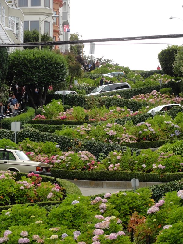
Lombard Street by Cynthia Lynch from Pixabay
Russian Hill
Significant Sites
- Ghirardelli Square – Italian Chocolate maker Domenico Ghirardelli came to San Francisco in 1853 from South America. His chocolate company is the 3rd oldest chocolate company in the country, but these days most people go to Ghirardelli Square to shop or to eat ice cream at the Ghirardelli ice cream parlor.

Ghirardelli Square
- Powell/Hyde Street Cable Car Turnaround – The Powell-Hide Street cable car turnaround is in front of Ghirardelli Square. Of the two lines that come down to FIsherman’s wharf, this one is the more popular so it usually has a longer line than the nearby Powell/Mason cable car turnaround. You can often find a street musician entertaining the people waiting in line.
- Lombard Street – Lombard Street is not the steepest street in the city, let alone the world, but it is the “The Crookedest Street in the World”. The best views of the street are from the bottom at Lombard and Leavenworth. It is fun to drive down, but what they don’t tell you is how nervewracking it is to drive up the backside of the hill.

Fisherman’s Wharf / North Waterfront
Significant Sites
- Fisherman’s Wharf – This is one of the most touristy neighborhoods in San Francisco. You can get fresh seafood here like a walk-away shrimp cocktail. You can buy a cheap t-shirt or more likely a cheap sweatshirt because you thought California would be warmer. There are still working fishing boats in the area.
- There are a number of museums at Fisherman’s wharf which range from historic to weird.
- Musee Mecanique – Old arcade games, ski ball, video games
- SS Jeremiah O’Brien – One of only 2 surviving Liberty Ships from the 2,710 built for World War II. The O’Brian was one of the supports ships for the D-Day invasion. The San Francisco Bay Area built many of these ships especially across the bay in what is now The Rosie the Riveter/World War II Home Front National Historical Park. There you can find one of the last Victory Ships.
- USS Pampanito (SS-383) – A World War II submarine that saw service in the Pacific. You can tour this boat for $20 adults / $10 kids

Hyde Street Historic Pier
-
- San Francisco Maritime National Historical Park – For history buffs this is a great stop. The park includes the Maritime museum but even better it includes the historic ships of Hyde Street Pier including:
- 1886 square-rigger Balclutha
- 1895 schooner C. A. Thayer
- 1890 steam ferryboat Eureka
- 1891 scow schooner Alma
- 1907 steam tug Hercules
- 1914 paddlewheel tug Eppleton Hall
- Cartoon Art Museum – I have not been to this museum since my kids were younger but we loved it then.
- Madame Tussauds Wax Museum
- Ripley s Believe It or Not! (Ripley’s Believe It or Not and Big Bus combo ticket)
- San Francisco Maritime National Historical Park – For history buffs this is a great stop. The park includes the Maritime museum but even better it includes the historic ships of Hyde Street Pier including:
- Powell/Mason cable car turnaround – This is the line that I recommend to ride back towards Union Square because its lines are usually shorter.

- Alcatraz Tours – If you booked in advance, maybe months in advance you can take one of the best tours in San Francisco of the Island Prison of Alcatraz. read Alcatraz Island – The Definitive Guide to Touring Alcatraz.
- Blue and Gold / Red and White Tours – This is where you can board one of the boats for a cruise around San Francisco Bay. The rival lines are in the colors of U.C. Berkeley and Stanford.

- Street Musicians and Entertainers – This area is where you can find more street entertainers and buskers than any other San Francisco neighborhood. But watch out for the bushman whose sole shtick is to jump out from behind two branches and surprise people.

- Pier 39 – Pier 39 is a shopping and entertainment complex. It is also where the California Sea Lions hang out on the west side of the pier. It has some of the best views of Alcatraz that you can get without getting on a boat. Pier 39 has a number of restaurants from simple to fancy as well as many shops and a carousel. It also has a stage with some of the best street performers. Pier 39 has a large parking garage but if you use an app like BestParking, you can often find cheaper parking a couple of blocks away.
- Aquarium of the Bay – This aquarium is located on Pier 39.
- Exploratorium – This hands-on science museum at Pier 15 is not just a museum for kids. This San Francisco institution is a great stop for nerds like me.
- Hornblower Cruises – Hornblower provides Bruch, Dinner, or Sightseeing cruises of the Bay. They board at Pier 3. Odd piers are north of the Embarcadero building and even piers are south of the Embarcadero building.

Coit Tower on Telegraph Hill
Telegraph Hill
This is one of San Francisco’s original 7 hills and was named for a semaphore tower that was erected on the top of the hill in 1849. This twoer was used to signal to the city when ships entered the harbor. The southern end of the Telegraph Hill neighborhood (which I would call part of North Beach but our map shows as Telegraph Hill) is Columbus Ave where you can find some great Italian restaurants like the historic Original Joe’s or one of my favorites Calzone’s.
Significant sites
- Coit Tower – Coit Tower was built in 1932-1933 using money left to the city by Lillie Hitchcock Coit. It was built as a memorial to volunteer firefighters. The interior, as mentioned above, is decorated with murals painted as part of the Public Works of Art Project (PWAP) during the depression. The resemblance of the tower to the nozzle of a fire hose is coincidental.

Washington Square Park San Francisco
North Beach
North Beach is San Francisco’s Little Italy and has been named one of the 10 best Italian neighborhoods in the country. You can still find lots of Italian restaurants in the area and a recreation area named for native son Joe Dimaggio. A North Beach food tour is a great way to explore the neighborhood.
The heart of North Beach is probably Washington Square Park and Saints Peter and Paul Church which looks up at Coit Tower.
I was once pitched an article on surfing in San Francisco in North Beach. There is no beach in North Beach and no surfing. Apparently, not everything you read on the internet is true. Who knew?
Significant Sites
- City Lights Bookstore – This eclectic bookstore is a San Francisco institution that is probably the best spot in the city to remember the Beat Generation.
Beach Blanket Babylon– This is a long-running only in San Francisco live performance musical known for its elaborate costumes will hold its last performances on Jan 1, 2020.

Transamerica Pyramid and American Zoetrope building
Financial District / Barbary Coast / Chinatown
This is San Francisco’s traditional button-down financial area which is the headquarters to companies like TransAmerica (in the Trans America Pyramid) and Bank of America. Bank of America was the Bank of Italy at the time of the 1906 earthquake and got a big boost because it was one of the first banks that started loaning money to rebuild, while the city was still smoldering.
But this area was also the area of Barbary Coast bars where a “sailor” might get passed out drunk and wake up on a ship to Shanghai. The northern part of this neighborhood around Broadway east of Columbus is seedier. That’s where you will find strip clubs and peep shows.
Significant Sites
- Transamerica Pyramid – The best views of the pyramid are on Columbus Street which deadends at the tower.

- Chinatown – The western edge of the Financial District runs up against Chinatown. San Francisco Chinatown is the largest Chinatown outside of Asia as well as the oldest Chinatown in North America. It was started by mostly people from Canton who came over to work on the Central Pacific Railroad or came over for the gold rush. These days you are as likely to hear Mandarin as Cantonese. Grant Ave is where the tourists go while the locals are as likely to shop on Stockton.
- Golden Gate Fortune Cookie Factory – In an alley off Chinatown you can still see people make fortune cookies from scratch. San Francisco claims to be the home of the fortune cookie (as does Los Angeles).

Nob Hill
California’s Big Four (also known as the 4 nabobs or nobs) “robber barons” who built the Central Pacific Railroad all built their mansions on Nob Hill: Leland Stanford (after whom Stanford University is named), Collis Potter Huntington, Mark Hopkins, and Charles Crocker. All 4 mansions survived the 1906 quake and fire, but have since been torn down. The only mansion left from that era is the one built by silver magnate James Clair Flood which is now the very exclusive Pacific-Union Club. The best way to become a member of this club is to have a grandfather who was a member.
This is now an area covered with luxury hotels. The Mark Hopkins hotel, the Stanford Court Hotel, and Huntington Park are named for 3 of the Big Four.
Significant Sites
- Grace Cathedral – San Francisco has two cathedrals. Grace is an Episcopalian cathedral built in a neo-Gothic style. The best part of Grace are the two labyrinths it has. One is outside and one is inside. Grace is across from the small Huntington Park.

- The Cable Car Barn and Museum – This is one of the sites I love to take tourists to before they ride a cable car, especially my engineer friends. A cable car has no motor. It just has a big set of pliers that it uses to grab onto a moving cable and this is where the big engines that drive the cables live. This is a free museum and a great stop.
- The Masonic Auditorium – This is a great concert venue. Check the schedule for events.

Downtown / Union Square
Downtown is one of the prime shopping districts in the city with high-end shops anchored by Union Square with its statue featuring Victoria, goddess of victory. The model for Victoria was Alma Spreckels who married sugar magnate Adolph Spreckels. She talked her husband into donating the money for the California Palace of the Legion of Honor museum by Land’s End. The square.
Gerry Street is where many of San Francisco’s theatres are, most only a block or two from Union Square. For that reason, the Square is also surrounded by high-end hotels like the Sir Francis Drake Hotel (now a Kimpton) where the doorman wears Tudor England garb.

Market Street has also routinely been a big shopping street. The Westfield San Francisco Center is a high-end urban mall. The best parking in the area (not the cheapest) is the large garage at 5th and Mission. Union Square has a parking garage under it that is a bit claustrophobic but convenient.

In the winter, an outdoor ice rink and a large Christmas tree can be found in Union Square.
While this is a POSH neighborhood, you will also seem some of the largest numbers of homeless along Market street in the evenings or even more so in the Tenderloin.
Significant Sites
- Union Square
- Theatre District – Theatres like the American Conservatory Theater, the Curran, the Marine’s Memorial Theatre are close to Union Square. The Golden Gate Theatre is just off Market Street a bit further west.
- Powell Street and Market cable car turnaround

Van Ness / Civic Center
This neighborhood is where you will find city hall and government buildings but it is also a center for arts in San Francisco.
Significant Sites
- City Hall
- Bill Graham Civic Auditorium – Bill Graham came to the U.S. after World War II and made a name as a music promoter. He brought groups like the Grateful Dead, Jefferson Airplane, and Janis Joplin’s band to the Fillmore auditorium. This downtown auditorium still holds rock concerts and other events.
- War Memorial Opera House – Across the street from City Hall is the city’s opera house. Opera has been performed in San Francisco since around 1850 and San Francisco was popular with touring companies and singers in the late 1800s. Tenor Enrico Caruso performed in San Francisco the day before the great 1906 earthquake. But San Francisco got it’s own opera company in 1923 and the opera house opened in 1932.

South Beach
Strolling along the Embarcadero in South Beach from the Ferry Building at the north to Oracle Park in the south is one of my favorite walks in the city. There are great views of the bay and the ships passing and of the Bay Bridge. There are also some large public art projects along the way. Until the 1989 Loma Prieta Earthquake, this area was a highway, and the conversion of it to parkland as well as the renewal of the area because of the ballpark has greatly improved this corner of the city.
Significant Sites
- The Ferry Building – Before the Oakland Bay Bridge in 1936 and the Golden Gate Bridge in 1937, this was the second busiest transit terminal in the world, second only to London’s Charing Cross Station. Now the building has come back to life with great food shops and restaurants. You can also still grab a ferry here.

- Oracle Park – As a San Francisco Giants fan I am biased but a discussion of the best baseball park in the United States at least needs to include Oracle Park. The cheap seats have a great view of the bay. Read more at Visitor’s Guide to Oracle Park – Home of the San Francisco Giants, including how you can get a glimpse of every game for free.

- The Oakland Bay Bridge – The Golden Gate Bridge is the more famous of the two San Francisco bridges but the Bay Bridge now has a great display of lights in the evenings.
Yerba Buena
This neighborhood is one of the most popular neighborhoods with visitors as it is the home to the Moscone Convention Center. When Salesforce is having its annual conference Dreamforce, for instance, there can be an extra 100,000 people in San Francisco. At that time hotel rooms are impossibly expensive. Dreamforce is held in early November. If you are not coming for the conference, come some other time.
Significant Sites
- Moscone Convention Center
- San Francisco Museum of Modern Art – If you like modern art I would recommend this museum over the De Young Museum in Golden Gate Park… but what do I know. I don’t like modern art.
Mission Dolores
The original San Francisco Mission now sits inside another of San Francisco’s great food neighborhoods. If you are looking for a burrito and so much more, this is the place to go. Which burrito place is the best can cause great debate among city residents.
Significant Sites
- Mission Dolores – The original mission building, the Mission San Francisco de Asis, is the oldest building in the city and dates back to 1776. It is still a functioning local church. It is just to the left of the more modern church.
Central Richmond
South of the Presidio is a neighborhood that tourists don’t usually visit but it is a great place to get some great ethnic food and to visit one of San Francisco’s most interesting independent book stores.
Significant Sites
- Clement Street – If you are looking for Burmese food, Vietnamese or a number of other different cuisines then dining out on Clement Street might be a good experience for you.
- Green Apple Book Store – This book store takes up most of the block that it is on.

Golden Gate Park
San Francisco’s largest park is Golden Gate Park in the north and west. This area used to be just sand dunes but was reclaimed over the years to build one of the best city parks in the country.
Significant Sites
- Windmills – At the west end of the park are a pair of windmills. The northern one, the Dutch Windmill, is surrounded by a garden of tulips.
- Japanese Tea House and Garden – This beautiful spot dates back to 1900. It is a lovely quiet corner of the city.
- de Young Museum – The de Young Museum is a modern art museum.
- California Academy of Sciences – This distinct building is covered with a living roof and hosts a variety of exhibits mostly around the life sciences. It includes a planetarium, an aquarium, a natural history museum, gardens, a 3D theater, and an aviary. It has two surprisingly good restaurants.
- Steinhart Aquarium – To visit the aquarium you must purchase a ticket to the Academy of Science.
- Golden Gate Park Carousel – This carousel is part of the Koret Children’s Quarter and dates back to 1914.
- Conservatory of Flowers – One of the oldest buildings in the park, the Victorian-style Conservatory of Flowers building dates back to 1876.

Lincoln Park / Land’s End
This green space is the northwest corner of the city includes a golf course, an art museum, a labyrinth, and some memorable cliffs.
Significant Sites
- Cliff House – This restaurant and event venue sites on the cliffs above the Pacific with great views. The original Cliff House was built here in 1858. The current one is the 5th version. The most beautiful version was the 3rd version built by Adolph Sutro in 1894.
- ruins of the Sutro Baths – Just north of the Cliff House are the ruins of a set of swimming pools also built by Adolph Sutro.
- Palace of the Legion of Honor – The Palace of the Legion of Honor is a fine art museum in a beautiful park. Some of this area used to be a graveyard but from 1920 to 1941 San Francisco moved all the graves out of the city some 150,000 of them down to Colma. Although it is now illegal to bury a body in San Francisco, rumor has it that Alma Spreckels might have found a way to hide the grave of her late husband somewhere on the grounds.
Podcasts
Learn more about San Francisco by listening to Travel to San Francisco, California – Amateur Traveler Episode 622.
and Travel to San Francisco, California – Amateur Traveler Episode 159
- Search for Great Tours HERE
- Get a Car Rental
- Book Your Accommodation HERE
- Buy Travel Insurance
- Save at San Francisco's Top Attractions with a San Francisco CityPass
by Chris Christensen
Chris Christensen is the creator of the Amateur Traveler blog and podcast. He has been a travel creator since 2005 and has won numerous awards including being named the "Best Independent Travel Journalist" by Travel+Leisure Magazine. He move to California in 1964.11 Responses to “Map of San Francisco by Neighborhood (16 You Should See)”
Leave a Reply
Tags: best, san francisco, san francisco bay area


Jennifer
Says:January 26th, 2021 at 12:23 am
Hi there, I am interested in your SF neighborhoods map. Is this image something we can purchase from you to print for a commercial setting?
Chris Christensen
Says:January 26th, 2021 at 3:52 pm
I purchased it so I can’t resell it. I don’t recall where I got it. but if you save it you can ask Google images to find images like this and give it an image.
JOYCE MCKINNEY
Says:January 30th, 2021 at 7:51 pm
Does a poster exist of the neighborhood map?
Chris Christensen
Says:January 31st, 2021 at 4:53 pm
Not that I am aware of and I don’t have the right to make one I think.
Matt
Says:July 26th, 2021 at 3:55 am
The neighborhood is spelled “Mission Doloresâ€, with an O. But also, I don’t this is the neighborhood to get a burrito. Instead here you will find Dolores Park, where on a sunny weekend day you’ll find eccentric picnickers and views of the skyline. This is also the most gentrified part of the Mission with boutiques and trendy eateries. Inner Mission is more likely where you’d find that burrito.
Chris Christensen
Says:July 26th, 2021 at 3:12 pm
Thanks Matt. If I could spell I would be dangerous.
Denny Smith
Says:January 1st, 2022 at 6:55 am
Chris, I admire the work and level of detail you invested in this survey. And the images are great.
I wish I could have had your ear for about 15 minutes when you were compiling this because just a handful of modifications would add a lot of vernacular relevance. For example, I don’t know anyone who makes distinctions between the “Middle†Richmond and Outer Richmond. Same with the Sunset. Likewise, “Middle†Sunset and “Outer†Parkside seem overly granular.
On the other hand, some details are missing or misrepresented—like Chinatown, The Embarcadero, Dogpatch, Polk Gulch, Valencia Corridor and the Castro! Those last three are ostensibly subsumed on the map by “Van Ness,†“Mission Dolores†and “Eureka Valley,†respectively, but no-one refers to those anymore as neighborhoods. Rather, Dolores Park and Mission Dolores are now subsumed by either the Castro or the Valencia Corridor, which runs between the Inner Mission and the Castro.
I’m not an urban archivist or historian, Chris, so I want to be humble, not cocksure. But I arrived here in 1974 and have seen so many things change, so many people drift in & pout out, it’s hard to pass up even minor corrections.
When I got here the beatniks & hobos had already signed off to hippies & bohos, who sorta evolved into drifters & dreamers or druggies & clubbies, with survivors going rural, the wounded living communal. Then a rebound came with refugees—the Pinoys & the gay boys, familias Latina & immigrants from Asia, then yuppies became the newbies, nimby’s the landed gentry, nighttime hipsters were daytime house flippers, with Gen X & Millennial techies moving from the Midwest and squeezing natives and boomers on social security. All this transpired against cycles-of-cycles of market-return inflation, vacancy-rate deflation, dot-com booms & drug-net busts, neighborhood gentrification, cultural strangulation, and now our creators of music, arts & letters are in economic exile.
The City is still potentially magical, and you beautifully describe that. It’s nice to hear it’s glories described afresh! There is a lot of marketing agenda out there, however. For example, more than a few of these neighborhood labels sound “stately but unreal,†so “real estate,†I suspect, may have manufactured them, for reasons that evade reality.
Here are some distinctions about which I am pretty confident:
* The Civic Center, the Tenderloin, Polk Gulch, Chinatown, The Embarcadero and Dogpatch can all stand independently.
* “Lower Pacific Heights†is actually not a ‘hood but an old joke, satirizing how some people south of true Pacific Heights wish they lived like “Specific Whites.â€
* Van Ness is merely a thoroughfare, not an area.
* South Park, the only oval neighborhood in SF, should be embedded in Soma.
* Forest Hill Extension, Mt. Davidson Manor and Westwood Highlands?—I never heard of these, and though they may exist in some dusty file, the wealthy owners of those properties are not so Balkanized, monastic or exclusive that they need their own tiny kingdoms like Monaco, Andorra and Vatican City.
There are other things on that map, I think, that don’t rise to the naming scale of Noe Valley, Potrero Hill or North Beach, but more research would be warranted for certainty. Best to visit different hoods and talk casually to a sprinkling of folks who live in them, then amalgamate their current usage. Neither City records nor business-sector spokes-people are better authorities on a community than people who live there.
So that’s my over-heated two cents, and we all know what a few pennies are worth today!
Chris Christensen
Says:January 1st, 2022 at 4:50 pm
The map was drawn by someone else, but when I wrote the article I was surprised that ever different map I saw drew the neighborhoods differently 🙂
Fidel Cano-Leon
Says:April 14th, 2022 at 8:28 pm
Chris, you have done a beautiful, full of information guide about San Francisco. Your time and efforts invested are appreciated. Best regards
Chris Christensen
Says:April 15th, 2022 at 2:11 pm
thanks!
Douglas Look
Says:March 5th, 2023 at 6:46 pm
Hi Chris–I was also interested in the source of the neighborhood map. FYI I tracked it down and it looks like it’s available through Shutterstock: https://www.shutterstock.com/image-vector/modern-city-map-san-francisco-usa-1024529167