Just about an hour north of San Francisco is Point Reyes National Seashore. It will feel even further away as Point Reyes is filled with hikes and open spaces. This 71,000-acre park is a great place for visitors and locals to take a break and take a hike.

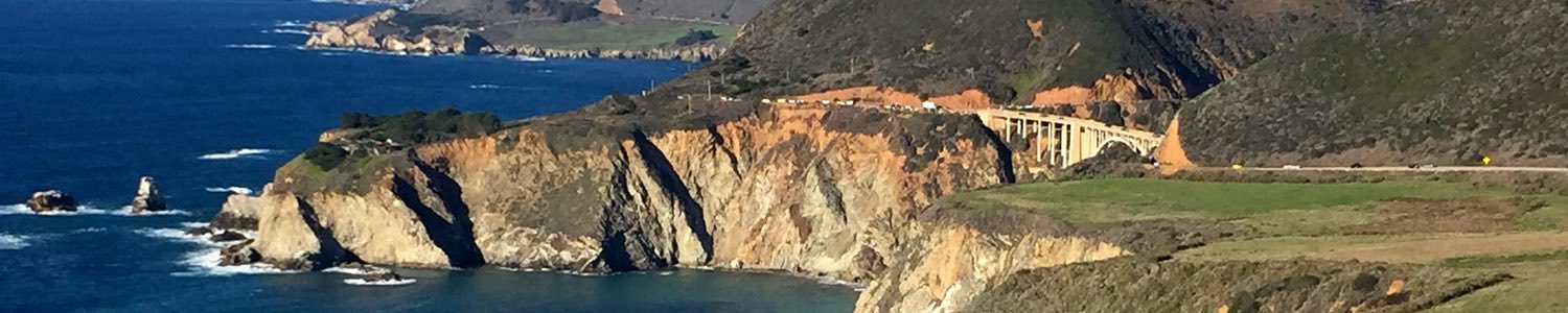
Point Reyes is a peninsula with 80 miles of coastline with a combination of rugged cliffs and empty sandy beaches as long as 11 miles long. It has some pirate, excuse me… privateer, history. It has wide open windswept pastureland. It has raging surf and a quiet bay perfect for kayaking.
Table of contents: ()
Best Hikes in Point Reyes
I have not done all 43 different marked trails in Point Reyes, but I have done a number of them. The trails range from 1.3 to 18.6 miles long. You can hike along a beach or in the hills that get up to around 1500 feet tall.

Wherever you hike in the park, stay on the paths and away from cliff faces. Also particularly in wooded areas, stay out of the green (and sometimes red) patches of poison oak unless you want to spend the rest of your vacation itching. Poison oak is found all along the California coast. Remember, “leaves of 3 let it be”.

Tomales Point Trail
One of the top-rated trails in the park according to alltrails.com and the one that I will recommend as the best is the Tomales Point Trail at the northern end of the park. The northern end of the park is a long thin peninsula that separates Tolames Bay from the Pacific Ocean. A park road runs up the peninsula only as far as Pierce Point Range and the McClures Beach trailhead. If you want to get as far as Tomales Point then you will need to hike.
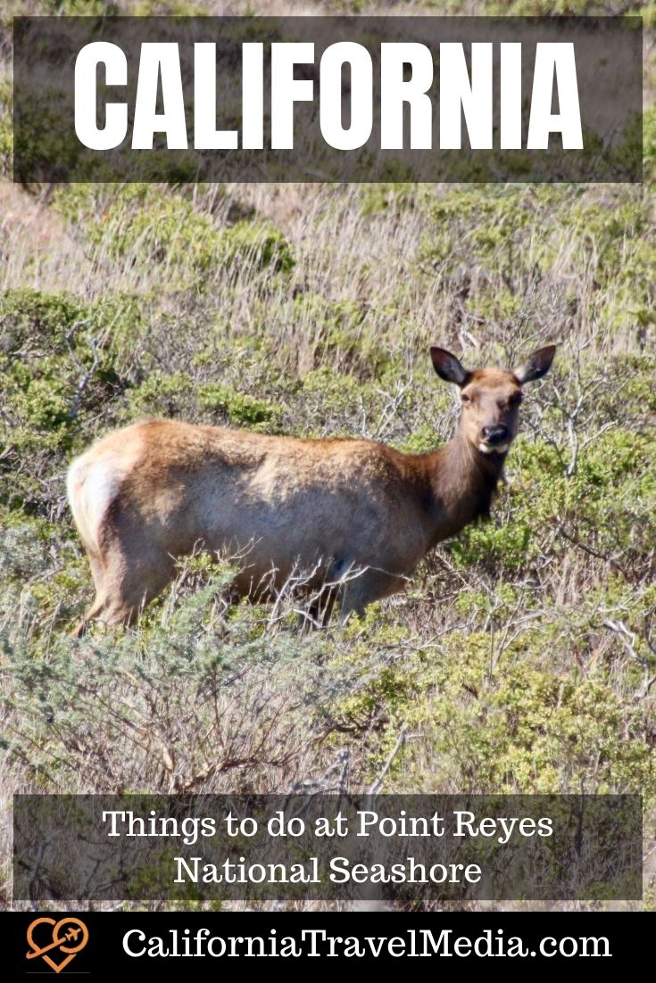
The hike is 9.4 miles to the point and back, but even if you don’t have the endurance for the entire hike, I would recommend you get out and hike at least the first mile and back. This is the best place in the park to find Tule Elk. We ran into half dozen just up the hill from Pierce Point Range.
Bear Valley to Coastal Trail Loop
One of the other longer (10 miles) hikes that we have done is the hike down the Bear Valley until it gets to the coast and then heading north on the Coastal Trail and taking that as it loops back inland. This tail, in the mainland portion of the park, has a nice variety of terrain.
Johnstone Trail and Indian Nature Trail
If you are traveling with younger hikers and want an easy half-mile one-way hike there are two that start from Hearts Desire Beach in Tomales Bay State Park (see below for best family beach). Tomales Bay State Park does have an $8 entrance fee.

Indian Nature Trail leaves from behind the restrooms on the left-hand side of the beach and heads up and over to the next beach along the bay. along the way, you will have an interpreted trail with signs about the local flora and fauna and how they were used by the native Miwok people. When you get to Indian Beach there are a couple of structures made to represent simple Miwok shelters.

If you head the other direction from Hearts Desire Beach you get the easy Johnstone trail. This will lead you to a group picnic area with a view of the main beach and then on to Pebble Beach. Pebble Beach itself is not a particularly compelling destination but the hike there through ferns, moss-covered trees, and rosehip plants is a beautiful stroll. More serious hikers can hike 5 miles further to shell beach.
Learn History in Point Reyes

Miwok Sweat Lodge at Kule Loklo
Kule Loklo – Miwok Village
When you are hiking the trails in Bear Valley tip your cap to the original inhabitants of this valley, the Miwok people. In the Miwok tongue, Bear Valey is “Kule Loklo”. Near the Bear Valley Visitor Center is Kule Loklo village which is a re-creation of a Miwok village. This is not a site of an original village so far as anyone knows. The Miwok people were hunters and gatherers from the rich local ecosystem. The Coast Miwok took advantage of the plentiful local seafood. They fished with surf nets and hunted with traps and bows and arrows.

Sir Francis Drake
The English privateer Francis Drake once took shelter beneath the clifts at Drake’s Bay. A privateer is like a pirate but with letters of mark from their king or queen to prey on enemy shipping. Drake had been pillaging his way around South America and up the Pacific Coast of the Americas before stopping at what would become Point Reyes National Seashore. In 1579, Drake and his crew spent 6 weeks in the local waters repairing a leak in his one remaining ship the Golden Hind. He was preparing to sail west across the Pacific instead of back south and back around Cape Horn into the Atlantic.
While Drake’s name is still associated with the area, the name he picked for it is not. He claimed this part of California for England and called it new Albion (“White Land” the oldest name for England) because its cliffs reminded him of home.

Half a dozen signs at the Ken Patrick Visitor Center near Drakes Beach (by the restrooms) tell the tale of Drake and his voyage. Drake would complete his circumnavigation and bring a queens ransom of treasure from his plunder back to Queen Elizabeth. His grateful queen would knight him for his efforts and thus we get Sir Francis Drake Boulevard in the park.

Dairy History
In between being a repair station for privateers and being a national seashore, the thing that Point Reyes was best known for was cows. The area was first a ranchero from 1836 with 8911 acres of land granted to Rafael Garcia who had been a corporal in the Mexican Army. He made good money selling beef to miners when gold was discovered in California in 1849 but quickly lost the land as land titles came into question under the new American ownership of California.
The Shafter brothers had large herds of dairy cattle in the area by 1957 and there are still 13 active ranches of the 31 their family would eventually found. The best place to see the history of the dairy business on this remote land is at the Pierce Point Ranch which is the trailhead for the Tomales Point Trail.
You can also purchase a self-guided audio tour that will narrate for you the ranching history of the area.
Or another way to enjoy the dairy tradition would be to stop at Cow Girl Creamery in Point Reyes Station for some locally produced organic cheese.

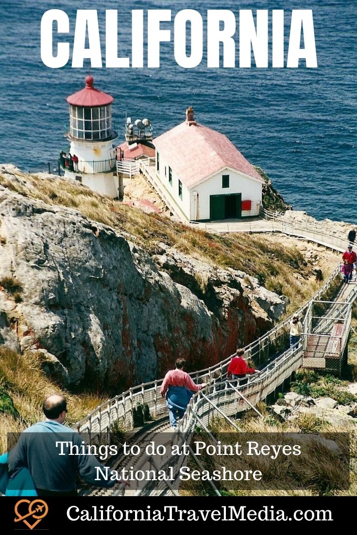
Point Reyes Lighthouse
The Point Reyes Lighthouse was built in 1870 to warn ships about the rocks on Point Reyes. It served for 105 years before being decommissioned. It is still a very popular place to visit in the park. Be aware that this area can have strong winds. I have been at the parking lot by the trailhead for the lighthouse when we were afraid to let our school-age kids out of the car for fear they would literally blow away. I think Point Reyes Lighthouse is one of the most beautiful lighthouses on the west coast.

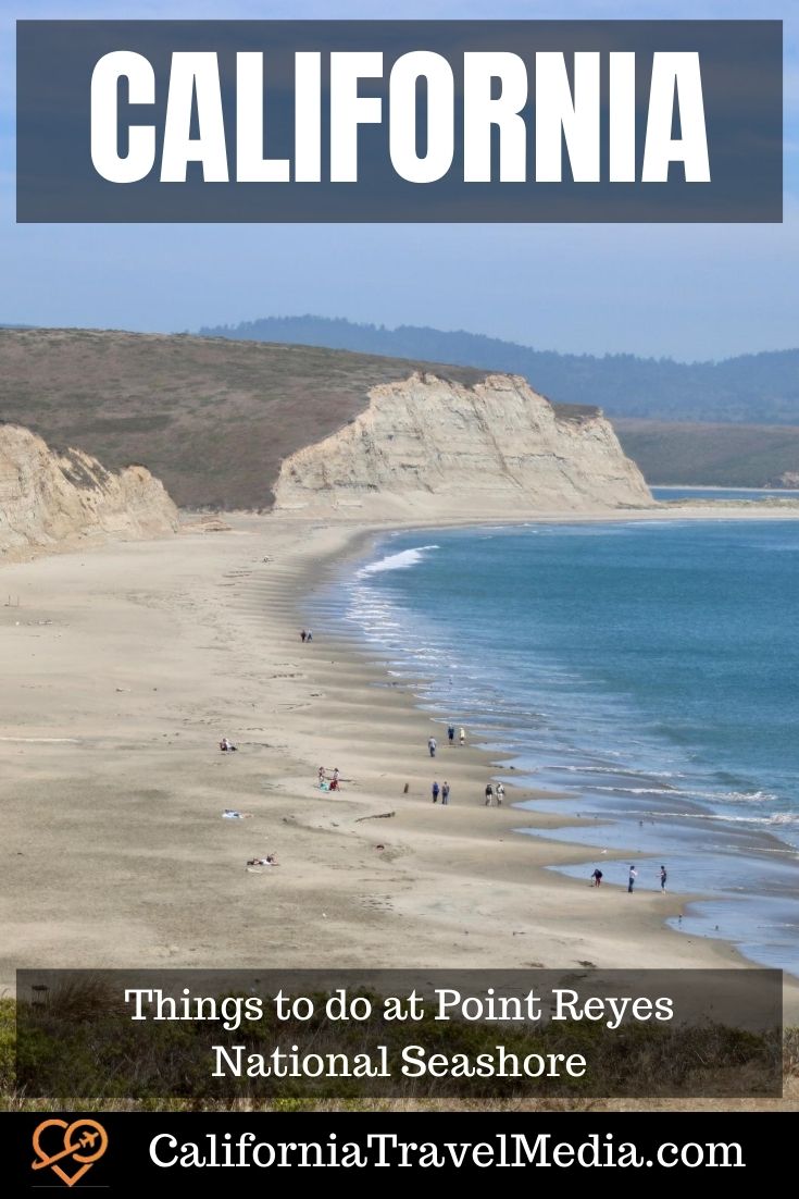
Claim a Beach
Francis Drake claimed all this coast for England… but it didn’t stick. But you can easily claim your own patch of it at least for the day. Point Reyes Beach on the Pacific side is 11 miles long. Drakes Beach is 4 miles long. Head half a mile from the parking lot and you will find yourself alone.
- Buy Travel Insurance
- Log your park visits with a Passport To Your National Parks
- Book Your Accommodation HERE
- Get a San Diego CityPass to save on the 5 best attractions.
- Search for Great Tours HERE
- Get a Car Rental

Best Sunset Beach
The honor for the best sunsets in Point Reyes is usually awarded to McClures Beach which is the north most beach on the Pacific side of the peninsula. The McClures Beach parking lot is just down the hill at Pierce Point Range and is the end of the road so you can’t miss it.

Best Beach for Families
One of the most popular beaches for families with small kids is Hearts Desire Beach on the Tomales Bay side of the peninsula. This beach is much smaller than Drakes Beach or Point Reyes Beach but is good for swimming as the water in Tomales Bay is much warmer (not warm but warmer) than the water in the Pacific. Also, unlike Point Reyes Beach, this protected beach does not have rogue waves that will grab you off the beach and an undertow that will drown you, which is also something I look for in a swimming beach.
There is one catch which is that Hearts Desire Beach is not part of the national seashore but is part of Tomales Bay State Park and has an $8 day-use fee per car.

Beachcombing
The beaches at Point Reyes are covered with driftwood and small shells. We saw a number of sand dollars on Drakes Beach when we last visited as well as crabs and parts of crabs.
Wildlife Viewing at Point Reyes

Tule Elk Preserve at Tomales Point
Tule Elk can be found in many places in the park, but the Tomales Point Trail is the most reliable place to see them. The Tule Elk are native to California but were nearly wiped out by hunting. They were thought to be extinct by the 1870s until a rancher near Bakersfield found a herd on his ranch. Now there are 5,700 known Tule elk in California.
Whale Watching at Point Reyes
Grey Whales migrate past Point Reyes in the winter months with peak sightings in January (southbound) and March (northbound). Bring your binoculars. The Point Reyes Lighthouse is one of the best spots to see them as it is on the point which extends farthest into the Pacific.

Birdwatching at Point Reyes
In addition to the usual seagulls and sandpipers, Point Reyes is home to vultures and red tail hawks which can be found all over the coastal California mountains. I have also seen red wing blackbirds there.
Small snowy plovers nest in the sand on the beach at Point Reyes Beach and the beach closes in the summer annually (between Memorial Day and Labor Day) on weekends and holidays from between the North Beach parking lot and the mouth of Abbotts Lagoon to preserve this endangered species.

Elephant Seals, Seals, and Sea Lions
Near Chimney Rock on the Point Reyes Headlands is a small beach that is frequented by Elephant seals. The greatest number of elephant seals are present in December through March. The elephant seal beach is closed to people but you can see them from the Elephant Seal Overlook.
Harbor Seals and California Sea Lions are also most plentiful in the same area near Chimney Rock.

Find a Fault
If you are wondering where the famous San Andreas earthquake fault is in California, Point Reyes National Seashore is one of the easiest places to spot it. Look again at the map at the top of this post. See how Tomales Point is a long tall northward peninsula that is separated from the mainland by the long skinny Tomales Bay. Tomales Bay is where the San Andreas Fault is located. Much of Point Reyes is on the Pacific Plate which is moving northward at 3-4 inches a year. So if you wait long enough to visit Point Reyes (in about 6 million years) you will have to go to Oregon.
Activities

Kayaking / Stand-up Paddleboarding
Tomales Bay might be one of the best places to learn sea kayaking or stand-up paddleboarding because it is a 15-mile long skinny bay protected from the wind by the hills of the national seashore. Many with their own gear will head out from Tomales Bay State Park which has a unit on either side of the bay.
You can also find a guided outing or lessons from a local outfitter such as Blue Waters Kayaking (bluewaterskayaking.com) or Tomales Bay Expeditions (tomalesbayexpeditions.com). With the correct permit, you can even do boat-in camping.
Horseback Riding
For equestrians, you can find horseback riding at Five Brooks Ranch in the southern part of the park. The trails in this area are a little less desirable for hiking because of the horse poop.
What to Wear
Point Reyes is a place to bring your best hiking shoes, but also bring a sweatshirt. This cool park in Northern California is almost always cool at night and often cool or foggy during the day.
You can bring your swimsuit but don’t swim on the long inviting Point Reyes Beach which is on the western / Pacific side of the park because there are strong rip currents. If you want to swim, choose a beach on the eastern / Tomales Bay side of the park-like Heart’s Desire Beach which will be both warmer and safer.

Point Reyes Station
The entrance to the main peninsula of Point Reyes runs through the small town of Point Reyes Station. Point Reyes Station is worth a quick stop.
Browse local foods and souvenirs at Toby’s Feed Barn. There is also a coffee bar at Toby’s and a two-room art gallery in the back. Or stop at Cowgirl Creamery for some local cheese from all those cows you saw at Point Reyes.

Before You Go
Point Reyes is a dynamic environment with bits of it needing repair or falling into the ocean all the time. Before you go, consult the temporary closures page on the official Point Reyes website. Our last visit was in August 2020 when park visitor centers were closed because of Covid-19 and major highway construction was causing delays. The road to the Point Reyes Lighthouse and Chimney Rock were also closed.
Point Reyes is a great place to get away from your cares… and your cell signal. This part of the California Coast has very spotty cell coverage so download or print out what information you will need before your trip. For directions, you might download the free map app from maps.me with downloadable maps.
Getting there is half the fun?
I would recommend you take your car or a rental car to visit Point Reyes National Seashore unless you purchase a private tour.
If you like winding roads, aren’t afraid of driving them with a lot of other cars, and don’t get car sick then just follow the directions your computer navigator will give you. From San Francisco take Highway 101 across the Golden Gate Bridge until you reach Highway 1 at Mill Valley. Follow Highway 1 all the way to the park.
However… let me emphasize the car sick statement above. The stretch of Highway 1 from Mill Valley to Stinson Beach is the most winding slow part of the entire Highway 1. It has curves marked with suggested speeds of 15 or 20 MPH in parts. There is no part of this that the word “highway” will seem appropriate. Whoever drew this road on a map followed a winding cow path… and the cow was drunk.
If you love to take curves in your sports car, this is your route. If that does not sound appealing then take the longer route through Navato or Petaluma on Point Reyes РPetaluma Road. This route also has a bonus that you can stop at Marin French Cheese for some great cheese such as their award-winning triple cr̬me brie specked with black truffles.
by Chris Christensen
Chris Christensen is the creator of the Amateur Traveler blog and podcast. He has been a travel creator since 2005 and has won numerous awards including being named the "Best Independent Travel Journalist" by Travel+Leisure Magazine. He move to California in 1964.Leave a Reply
Tags: marin county, national park, point reyes national seashore